In October 2023, I attended the English Setter National Specialty in Asheville, North Carolina and used that as an opportunity to visit four national parks and chase some fall colors.
Clicking on the images in this post will enlarge most for a better viewing experience.

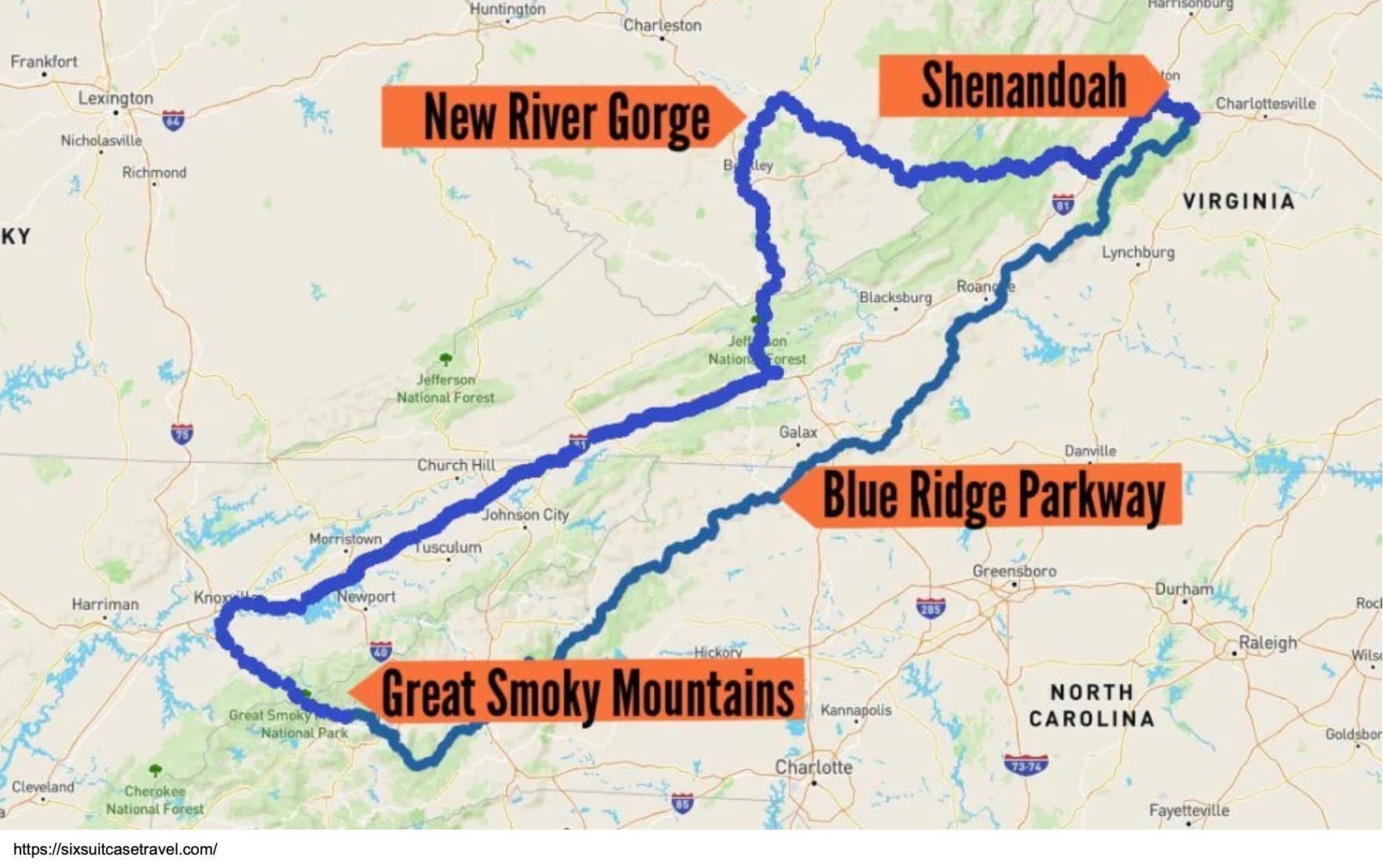
Come join me for some highlights of my loop from Asheville, NC that included Great Smoky Mountains National Park, the Blue Ridge Parkway, New River Gorge National Park and Preserve, Babcock State Park, Shenandoah National Park, and Congaree National Park.

This post will not include Congaree. You can read about my experience there in a previous post “In Search of the Swamp Fox“.
After learning a little about the Appalachian Mountains in general, you will have the opportunity to choose the places you are most interested in if you don’t want to read this entire article.
A Little Science and History

The three national parks covered in this post are all located in the Appalachian Mountain range which runs 2,050 miles from Newfoundland in Canada to central Alabama. It is the oldest mountain range in North America having its beginnings 1.1 billion years ago when large landmasses collided causing an upward buckling of land during the formation of the supercontinent Rodinia. Through a series of geological events, the mountains continued to rise and eventually reached heights similar to those of the present day Rocky Mountains. About 335 million years ago, a supercontinent called Pangea was assembled in which North and South America were contiguous with Africa and Europe. This supercontinent broke up as tectonic plates moved in opposite directions forming the Atlantic Ocean about 175 million years ago.
So you may ask, why is this important? It turns out that the Appalachians are not unique to North America, and I find this to be an interesting tidbit.

The Appalachians were once part of a mountain range called the Central Pangean Mountains. The Pangean break up ripped this mountain range in half. Sections of the former range remained with the different continents as they drifted to their present locations. The Appalachian Mountains of North America, the Scottish Highlands, all of Ireland, parts of Greenland and the Atlas Mountains of Morocco are all remnants of this ancient mountain range.
The process of mountain building ceased about 240 million years ago, and natural erosion has degraded these ancient mountains to what we see today. Although we continue to call them the Appalachian Mountains, they are now technically termed the Appalachian Highlands. I grew up in the Appalachians, and they sure seemed like mountains to me!
Although the Appalachians are not spectacularly high mountains, they are quite rugged and served as a natural barrier to westward expansion during the settling of the United States. For the early settlers, there were only three places where animal assisted travel could cross the mountains. These were the Gaps of the Allegheny in Pennsylvania, the Cumberland Narrows of western Maryland, and the Cumberland Gap at the tripoint of Kentucky, Tennessee, and Virginia. In 1775, the now famous Daniel Boone and 30 men set off to cut a road through the mountains using only axes! He set off from near present day Kingsport, Tennessee, followed a Native American trail called the Great Warrior’s Path, crossed through the mountain range at the Cumberland Gap, and eventually ended in Madison County, Kentucky. The resulting route was named the Wilderness Road.
This map shows the routes settlers followed from the population centers of the mid-Atlantic to the “west”.

Between 1775 and 1810 more than 300,000 settlers used this road to Kentucky and the Ohio Valley. The road also allowed the passage to the east of produce from farms and goods flowing west for the settlers. However, use of this road declined by 1840 as technological advances allowed for other forms of transportation, notably waterway transit, to allow passage from the east side of the mountains to the west.
When you hear people talk about hiking the Appalachian Trail, they are usually referring to the AT in the United States which stretches stretches more than 2,190 miles from Springer Mountain in Georgia to Mount Katahdin in Maine. The AT is the world’s longest hiking-only trail and has extensive sections in two of the three parks in this post. The International Appalachian Trail (IAT) adds an extension all the way through Newfoundland and Labrador in North America.
The IAT now winds extensively through Ireland, Scotland, Wales and England along with short sections in Spain and Morocco. Extensions are planned in Europe and Scandinavia.


Visiting the three national parks that are the subjects of this post allows you to view the rugged beauty of these mountains and imagine the difficulties they posed to westward expansion.
If you do not wish to read this entire post, you can click on any of the following links to go to the section you would like to learn more about.
- Great Smoky Mountains National Park
- Blue Ridge Parkway
- New River Gorge National Park and Preserve
- Babcock State Park
- Shenandoah National Park
Great Smoky Mountains National Park

Great Smoky Mountains National Park (GSMNP) occupies over 800 square miles (522,427 acres) in the southern Appalachian Mountains straddling the border of North Carolina and Tennessee with about half of the park in each state.
The Great Smoky Mountains are a part of the Blue Ridge Mountain region of the larger Appalachian Mountain chain.
The Smoky Mountains got their name from a haze that looks like smoke, but is not smoke, as seen in this photo. What is the origin of this haze?

The Great Smoky Mountains are thickly vegetated and receive more than 60 inches of rainfall annually with a fairly cool average annual temperature of 45o F. Due to this large rainfall and mild climate, the Great Smoky Mountains are technically a temperate rainforest. The humidity, cool temperatures and altitude of the mountains provide a perfect environment for low level cloud formation. During respiration, the dense vegetation produces oxygen and organic compounds called VOC’s (volatile organic compounds). These VOC’s are small molecules that have a high vapor pressure (meaning they are released easily into the atmosphere at room temperature). These small organic molecules are not very water soluble so they become suspended in the clouds forming the characteristic haze.
Of the 63 national parks, Great Smoky Mountain National Park ranks 19th in size at 522,427 acres. The largest park in the system is Alaska’s Wrangell-St. Elias National Park & Preserve at 13.2 million acres and the smallest Gateway Arch National Park in Missouri at 192.8 acres. Great Smoky Mountains was the most visited of all the parks with 13.3 million recreational visits in 2023. The next most visited park was Grand Canyon National Park at 4.7 million. GSMNP has been visited by more than half a billion people since 1934.
In 1926, President Calvin Coolidge signed a bill that would establish two new national parks, Great Smoky Mountains and Shenandoah, once land could be acquired for them. A total of 150,000 acres of land had be purchased before GSMNP could be created. Since the federal government was prohibited from buying lands for the making of national parks, the task fell to the states of North Carolina and Tennessee along with private citizens and organizations. By 1928, $5 million had been raised, and The Laura Spelman Rockefeller Memorial Fund matched this amount to purchase the needed land.
In 1934, building of public facilities began making Great Smoky Mountains the 21st park in the system. The Civilian Conservation Corps (CCC) built many of the trails, campgrounds, buildings and stone bridges still found in the park today. President Franklin Roosevelt formally dedicated the park in September of 1940.

If you asked what national park a person should visit to see flora and fauna, you would probably be told to go to Yellowstone. While Yellowstone is known for its wildlife, it turns out that Great Smoky Mountains National Park possesses the greatest biodiversity of any park in the system. In fact, there is no other area of equal size in a temperate climate with such an extensive biodiversity. While more than 19,000 species have been documented inside the park, scientists believe they probably have only discovered about a fifth of the species found there.

Great Smoky Mountains NP is home to more than 240 bird species, 67 native fish species, 65 mammal species (Manitoban Elk in photo), and 80 reptile and amphibian species.
The most iconic mammal species in the park is probably the black bear. Approximately 1,500 black bears call the park home although I did not see one on this trip to the park.
Only 16 of the 63 national parks do not charge entry fees that can sometimes be a bit pricey. You would think with so many visitors, charging an entrance fee would provide welcome funds for operating GSMNP.
So why is there no entrance fee? It is the result of historic legal actions. When the state of Tennessee transferred Newfound Gap Road (Hwy 441) and Little River Road (Hwy 71/73) to the national park in 1951, it did so with a restriction preventing tolls from ever being imposed on either road. In 1964, a federal law was enacted (1994 {1964} U.S. Code Title 16) which prevented the National Park Service from charging entrance fees anywhere that tolls are prohibited on primary park roads. Since the Newfound Gap Road and Little River Road are the main roads in the park, no entrance fee can be charged. While there is no fee for entrance, in 2023, the park began charging a $5 fee per day to park anywhere within the park. So if you are never going to stop and get out of your vehicle, the park is free otherwise you need to pay the parking fee (annual or lifetime passes do not cover this fee.) The park also charges fees for camping.
One way to enjoy the park is on one or more of the 150 official trails which cover about 850 miles and include 70 miles of the Appalachian Trail (highlighted in red on the map).


There are also 384 miles of paved and gravel roads in the park, most of which are suitable for ordinary passenger cars.
Although I visited the park quite a bit when I lived in Kentucky, on this trip we spent a day looking for fall colors by driving Newfound Gap Road which is highlighted in yellow on the map above.
Auto touring provides expansive scenic views as well as access to beautiful mountain streams, mature hardwood forests and historic buildings.

There are four grist mills (mills that grind grains and corn into flour) located in the park. The Mingus Mill, built in 1886 and rehabilitated in 1968 is still functional today. There are 18 named waterfalls in the park, three of which can be accessed from a road without hiking.
Great Smoky Mountain National Park is a great place to add to your bucket list if you have not been there. Summer is a very popular time, attracting the largest number of visitors. Personally, I prefer both spring with its new leaves on the deciduous trees, flowers, gushing waterfalls and baby animals and fall with its beautiful, multicolored leaf displays.
The Blue Ridge Parkway

The Blue Ridge Parkway, often called “America’s Favorite Drive”, meanders for 469 miles through the Blue Ridge Mountains of the Appalachians connecting Great Smoky Mountain National Park with Shenandoah National Park. It is the most visited of all the National Park Service sites with 16.8 million visits recorded in 2023.
This slow paced route is intended for immersing yourself in the beauty of the mountains with speed limits of 45 mph and often less. In general, one should expect to cover about 30 miles of road in an hour without lengthy stops. The route can be driven in 9-10 hours, but most people take several days to complete it. If you do not have several days for exploration, you can access the route in a number of locations along its length and just drive a section. I did not have the luxury of several days so I did one short section on my way from Asheville to New River Gorge National Park and another from Shenandoah National Park south on my way to Congaree National Park. If you have the time to spend, there are lots of hiking trails to explore along with auto touring. I was interested in driving part of this route because my parents spent their honeymoon driving the Blue Ridge Parkway and Skyline Drive back in the early 1950s.
New River Gorge National Park and Preserve
The next stop on the loop was New River Gorge National Park and Preserve in West Virginia, a new national park to visit for me. When combined with Congaree, it brought my total of visited national parks to 53 of 63.

The New River flows 360 miles through North Carolina, Virginia and West Virginia, starting in North Carolina and ending its journey in Charleston, West Virginia when it becomes part of the Kanawha River. It is one of the few rivers that flows in a northern direction.
The name “New River” is truly a misnomer as it is considered one of the oldest rivers in the world. It is estimated that the river was born 260 million to 325 million years ago. As the mountains rose around the river, it eroded the bedrock at the same rate as mountain formation leaving behind deep canyons through which the river runs. One of these is the 1,600-foot deep canyon now known as the New River Gorge. By definition, a gorge is a narrow valley with steep walls located between hills or mountains usually carved by a river or stream. The New was once a longer river which geologists called the Teays River which continued on through central Ohio, Indiana, and Illinois to eventually empty into the Mississippi. About 10,000 years ago, the advance of glacial ice buried a large portion of the river diverting its water into the Ohio and Kanawha rivers that had been created by glacial action.
A 53-mile section of the New River flows through New River National Park and Preserve. Over this 53-mile journey, the river drops 750 feet in elevation (compare this to the drop in the Mississippi River of only 1,428 feet on its 2,300 mile journey from Minnesota to the Gulf of Mexico). This creates a whitewater course that contains many rapids ranging from Catagory I-IV making the New River popular with white water enthusiasts.
New River Gorge became the newest national park on December 27, 2020. This area had been established as the New River Gorge National River in 1978 by Jimmy Carter “for the purpose of conserving and interpreting outstanding natural, scenic and historic values and objects in and around the New River Gorge, and preserving as a free-flowing stream an important segment of the New River in West Virginia for the benefit and enjoyment of present and future generations.” In 2023 New River Gorge NP ranked 17th in park visitations with 1.7 million visits.
The National Park and Preserve encompasses 72,808 acres of which 7,021 is national park and 65,165 is the national preserve.
You may wonder why there is a preserve designation. Although both the park and preserve are managed in the same way, a national preserve allows regulated hunting, fishing and trapping for both sport and subsistence. When the area was a national river, the entire area allowed for these uses while the national park designation prohibited these activities.

The New River region has a long cultural history. Although it was first explored by European fur-traders in the 1600s, Native Americans had lived in the region for centuries. The Shawnee was the primary tribe when the Europeans arrived and conflicts ensued. During the westward migration, few people stopped to settle West Virginia instead moving on to Ohio and the midwest where crops could be raised on flat fertile fields. Those that did stop in West Virginia became known as mountaineers who lived off the land as subsistence farmers growing enough crops to sustain only themselves on the small patches of land that were farmable, by hunting game and gathering wild plants. It was a difficult isolated existence.
After the Civil War, the New River Coalfield was discovered. The coal in this field is a very high quality bituminous coal which is a low volatile coal, known as “smokeless” coal.

Commercial coal mining began in the 1870s and thrived until the mid-20th century. At one time, there were at least 60 coal towns in the New River Coalfield, of most there remains no trace.
In the 1870s, the Chesapeake and Ohio Railroad (C&O Railroad) built a mainline which stretched from Richmond, Virginia to the Ohio River through West Virginia. It opened southern West Virginia to the outside world changing it forever. Building a rail line through the mountainous terrain was a monumental undertaking and most of the work was human-powered, using only hand tools and explosives – not machinery. It was the building of this line from which the legend of John Henry sprang. This rail line allowed industries that harvested natural resources such as coal mining and logging to thrive. These resources helped fuel the United States’ Second Industrial Revolution (aka the Technological Revolution, 1870-1914) ushering in the modern era. Although C&O’s passenger services ended in 1971 with the formation of Amtrak, Amtrak’s tri-weekly Cardinal passenger train follows the historic and scenic route of the C&O through the New River Gorge allowing passengers to experience this rugged section of West Virginia in comfort.
New River Gorge National Park and Preserve has something for just about everyone. You can visit historic sites such as the preserved Trump-Lilly subsistence farm, the former boomtown of Thurman, enjoy spectacular scenery, explore miles of hiking trails, and seek whitewater thrills to name a few.
During my day and a half in the park, I opted for scenery viewing and hiking mainly in the southern region of the park.


I entered the park from the south driving along the New River to Sandstone Falls. Remember this river flows in a northern direction. This is the point at which the river transitions from a broad, lazy bottomland river to a narrow, fast moving mountain river raging through a V-shaped, boulder-filled gorge. Sandstone Falls stretches 1,500 feet from bank to bank where there are shelves over which the river drops separated by rock islands. The river drops 25 feet at the main section of the falls.

At the falls, the river flows over a layer of sandstone that caps a soft conglomerate rock layer composed of small rocky fragments that are held together by fine-grained sediments such clay or sand.
Over time, the river washed away the conglomerate layer beneath the harder sandstone creating the falls. This process is still in progress, and the falls are slowly advancing upstream.
From the Sandstone Falls Day Use area, you can walk a trail that takes you across two islands to see the main section of the falls. You can also do a loop walk on one of the islands to see the unique flora community that is found in only five other places. Sandstone Falls is a sight not to be missed.
I wanted to see the New River Gorge so I next went to the Grandview Area which is high on the rim of the gorge. This photo shows how the river twists and curves between the steep walls of the gorge. Note, similarly to the Great Smoky Mountains, the vegetation here produces VOCs which mix with moisture in the air to cloak the mountains in haze as seen in this early morning shot.


I hiked the 3.2-mile roundtrip Grandview Rim Trail from the Grandview Main Overlook to the Turkey Spur Overlook.
Although the trail is rated as moderate, except for a few short, somewhat steep sections near Turkey Spur, it is not a very difficult hike. If you do not want to hike the roundtrip and have a second vehicle or someone who does not want to do the hike, there is a parking lot at Turkey Spur where you can be picked up after 1.6 miles.
This horseshoe curve of the river 1,500 feet below is one of the breathtaking views seen from the Grandview Rim. These views were made even more spectacular by the fall foliage. Here you are seeing almost 5 miles of river.

YoYo Ma, the world-famous cellist, was so inspired by this view that he gave an impromtu concert at the main overlook playing passages from Aaron Copeland’s “Appalachian Spring”.
If you look across the river, you can see the train tracks that are still used mainly by freight trains. One can get a unique look at an entire long freight train from this vantage point. The views from the rim are truly inspiring.

To finish out my stay in New River Gorge National Park, I drove to the northern end of the park to visit the Canyon Rim Visitor Center and see the famous New River Gorge Bridge, icon of the Park.
The New River Gorge Bridge was completed October 22, 1977. In the past, from where the bridge now spans the river, it took more than 40 minutes traversing narrow, winding mountain roads and crossing the river on an old, rickety bridge. Completion of the bridge cut the river crossing to a one minute drive! Building this bridge was a major technical challenge and ended up creating a structural piece of artwork.
The New River Gorge Bridge is the longest steel single span bridge in the western hemisphere at 1,700 feet and the second highest bridge in the United States at 876 feet above the river (325 feet taller than the Washington Monument).


This bridge is one of the most photographed places in all of West Virginia, and in 2005, the U.S. Mint chose it to represent West Virginia on the state’s commemorative quarter.
After driving across the bridge, I walked down a trail from the rim to get some different views of the structure. For a really unique adventure, you can do a guided 3-hour bridge walk where you traverse the bridge on a catwalk underneath the bridge. I didn’t have time to do this, but it is definitely something I would like to return to do.
Babcock State Park
After visiting the bridge, I continued my drive around the Park on the New River Gorge Scenic Drive to reach Babcock State Park which is home to a fully operational Grist Mill.
Milling was a common activity in the Appalachian Mountains until the 1950s.

The mill was constructed from parts salvaged from older mills that had ceased operation. The main structure came from one mill, the waterwheel from another, and other miscellaneous pieces from a third mill. This mill is situated on Glade Creek very close to the spot formerly occupied by Cooper’s Mill on this creek. Glade Creek Grist Mill is a fully operational mill that grinds corn into cornmeal. In the past, a person brought corn to the mill for grinding. In exchange for the grinding, the miller charged a fee of about 10% of the cornmeal produced. If a person didn’t have corn, he/she could “buy” a sack of cornmeal from the miller. In those days, people in the Appalachians usually had little money so they bartered, trading things like milk, butter, eggs, vegetables, nails, lumber, etc. for a sack of cornmeal. Today, you can buy the cornmeal ground at the mill in the state park’s gift shop.
It is said that this is the world’s most photographed grist mill. The fall colors made for a truly beautiful scene.
Shenandoah National Park
Shenandoah National Park consists of 199,173 acres spanning the crest of the Blue Ridge mountains between the Shenandoah Valley to the west and the Piedmont region to the east only 75 miles from Washington DC. The Skyline Drive, with its many scenic overlooks and trailheads, runs the entire length of the park from north to south a total of 105 miles (denoted by red and yellow lines on the map). It is the only public road through the park and takes about 3 hours to drive if you don’t do a lot of stopping. The park is so long and skinny that it is typically divided into three districts – north, central and south, each approximately 30 miles in length. The central district tends to be the most visited of the three.
The park contains more than 500 miles of hiking trails and almost 80,000 acres of designated wilderness. There are 101 miles of the Appalachian trail in Shenandoah National Park. The trail often follows the path of the Skyline Drive crossing it several times. One can easily day hike portions of the AT within the park.


As previously mentioned, a bill was passed in 1926 to create both GSMNP and Shenandoah once land could be acquired. The State of Virginia purchased about 190,000 acres of land and donated it to the federal government. The park was established in 1935 and dedicated by FDR on July 3, 1936.
How the land was acquired is not the nicest of stories. Shenandoah is located where settlers had lived for more than a century before the park was established. The State of Virginia used eminent domain, the right of government to expropriate private property for public use with payment of compensation (which can be below market value) to acquire much of the land. It condemned and acquired the homes and farms of 465 families for the park. While most of these people left peacefully relocating outside the park, some did not. There are stories of people who barricaded themselves inside their homes, were arrested and forcibly removed. Others filed suits that they did not win claiming that seizure of their land violated the Fourteenth Amendment’s due-process clause.
Shenandoah was the first of the national parks to be created from land that had been highly impacted by human activity. This land had been farmland and contained second- or third-growth forest resulting from being logged since the early 1700s. A trip through the park shows how forests well have regenerated.


Shenandoah was the first national park to make use of the Civilian Conservation Corps. Between 1933 and 1942 approximately 10,000 CCC boys built most of the infrastructure still used by park visitors today. They built hiking and horse trails (including the AT), picnic areas, campgrounds, buildings and constructed the Skyline Drive and its overlooks during the 1930s. Most of the timber, rocks and other materials they used were locally sourced.
Since I was limited on time and had been to Shenandoah previously, my visit only included driving about the southern 60% of the Skyline Drive before heading south to pay a visit to Cogaree National Park.
If you would like to take a trip on which you can see spectacular scenery either by car or hiking, maybe learn a little history, or participate in an adrenaline producing activity, I would recommend the sites on this loop.
Although most of this loop could be done in any season, some higher altitude areas might be difficult to access in winter while summer in the southeast can be a bit warm and humid. Summer is when there are the largest crowds. Visiting during either spring or fall would be my recommendation. To do the entire loop justice, I would suggest at least a week to 10 days especially if including Congaree. Of course, you could visit just any one of these incredible places for a great vacation.